N.C. Forest Service - Forest Preharvest Planning Tool (FPPT2)
Before beginning any timber harvesting operation, the N.C. Forest Service recommends developing a preharvest plan. This plan should include the locations of harvest activities, information about sensitive areas found on a tract and practices needed to prevent or reduce impacts on the natural environment. Creating and implementing a preharvest plan can improve efficiency and communications, reduce risks to water quality and increase landowner satisfaction. A preharvest plan can also help the logger save operating costs, such as wear and tear on equipment, and additional work or rework if found out of compliance with the FPGs. See Chapter 3 of the BMP manual for further details and recommendations on preharvest planning.
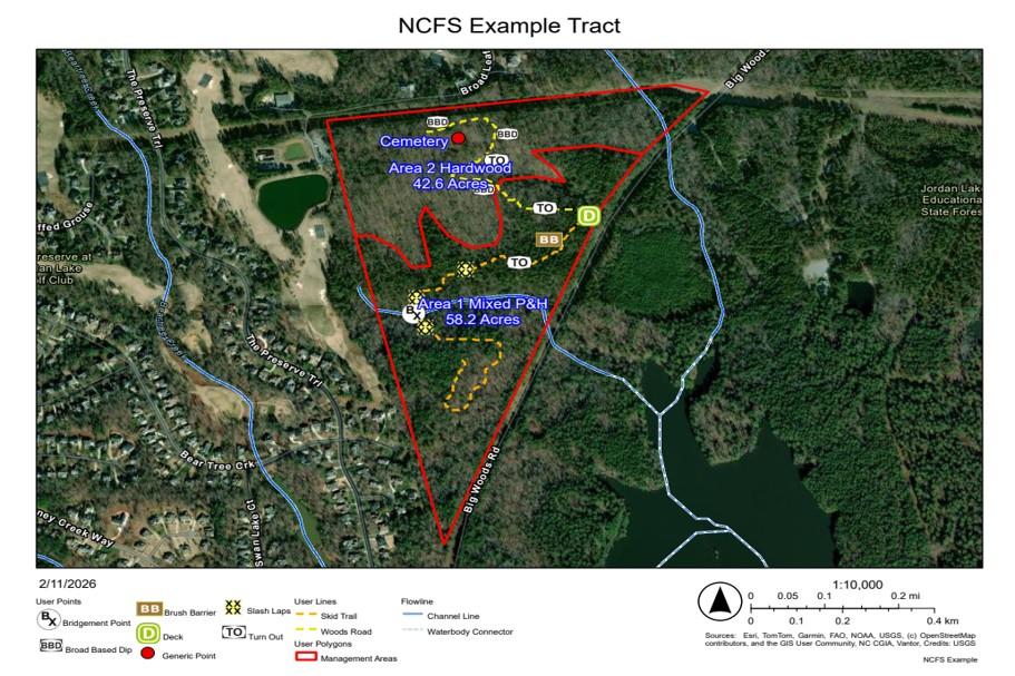
The N.C. Forest Service has created the Forest Preharvest Planning Tool (FPPT) to assist loggers and forest landowners with preharvest planning. An updated version referred to as FPPT2 was developed. This version features many of the same map options and tools, but does not require an account for users. The tool is an excellent way for forest operators and forest landowners to create customizable maps. FPPT2 has an improved online interface, and remains free and publicly available. Note that each Friday at midnight, FPPT2 will automatically reset and delete any user inputs in the system. For example, if you make a map during the week, we recommend that you export your work and save the map to your computer or device before midnight Friday.
Users can show/hide map layers to facilitate informed choices. For example, the most recent printed version of the soil survey manuscript is a layer that can be shown to help identify where riparian buffer rules may apply (see forestry leaflets on the Riparian Buffer Rules webpage). The user can also create a tract map that shows the locations of harvest features such as skid trails, streamside management zones and decks. The tool has the option to add more than a dozen best management practices (BMPs) features including broad based dips, bridgemat points and water bars. This option can help you identify and mark BMPs to use during or after the harvest has been completed.
The FPPT2 is a powerful information gathering and planning tool, but it should still be supplemented with a preharvest site inspection by natural resource professionals, e.g., forester, forest operator, timber buyer, before the forest management operation occurs. Be sure to review the five steps of preharvest plans for BMPs in Chapter 3 of the BMP manual.
We believe this tool will save forestry interests both time and money by improving preharvest planning efficiency and communications.
If you have questions or feedback, please email the NCFS Water Resources Branch (WRB) at NCFS.Water@ncagr.gov.
Additionally, if you have a group of 25 or more people that would like an in-person demonstration of the tool, please contact us at NCFS.Water@ncagr.gov to request arrangements. Forest Service staff can bring the demonstration hardware to your location and help your group get started with online preharvest planning.
The original NCFS FPPT will remain accessible until June 30, 2026, and users of this version are encouraged to download and save their created maps and data before closure.
This page was last modified on 06/24/2026